

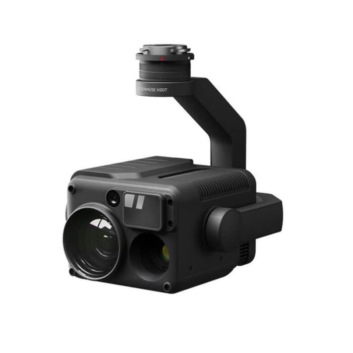
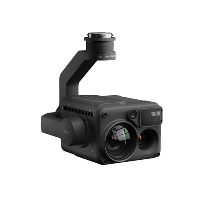
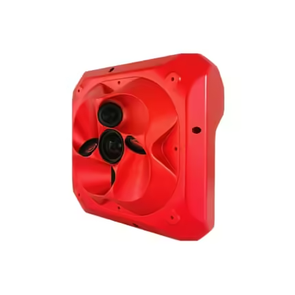
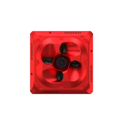
DJI Zenmuse H20T – Thermal Camera for Drone
₹819,000.00
General Specifications:
Weight: 828±5 g
Dimensions: 167 × 135 × 161 mm
Ingress Protection Rating: IP44
Operating Temperature: -20° to 50°C (Temperature measurement is available between -10° to 50°C)
And many more…
3 in stock
- 7 Days Return, Exchange & Refund Policy.
- Free Delivery within 3 to 5 Days.
- Assured Product Quality. We deal with only Genuine Products.
- Peace of mind Warranty. Check Our Warranty Policy.
- Contact Us for Any Assistance.
Guaranteed Safe Checkout
Exploring The DJI Zenmuse H20T: A Game-Changer In Aerial Imaging
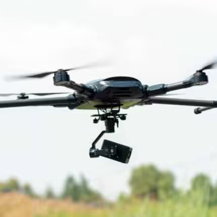
When it comes to professional aerial imaging, the DJI Zenmuse H20T is a standout payload that revolutionizes how industries operate. Designed for use with the Matrice 300 RTK and Matrice 350 drones, the H20T offers an impressive combination of high-resolution optical, thermal, and zoom capabilities, making it ideal for various applications, from public safety to infrastructure inspection.
VISIT THIS CATEGORY PAGE TO EXPLORE THE THERMAL
What Is The Zenmuse H20T Used For?
The DJI Zenmuse H20T is primarily used for tasks such as search and rescue, infrastructure inspections, disaster management, and environmental monitoring. Its multi-sensor capabilities allow professionals to gather crucial data efficiently and accurately, enhancing decision-making processes in critical situations.
Detailed DJI Zenmuse H20T Specs
General Specifications
Weight: 828±5 g
Dimensions: 167 × 135 × 161 mm
Ingress Protection Rating: IP44
Operating Temperature: -20° to 50°C (Temperature measurement is available between -10° to 50°C)
Storage Temperature: -20° to 60°C
Laser Safety: Class 1M (IEC 60825-1:2014)
Supported Aircraft: Matrice 300 RTK
Gimbal Features
Angular Vibration Range: ±0.01°
Mount: Detachable
Controllable Range:
Pitch: -120° to +30°
Yaw: ±320°
Mechanical Range:
Pitch: -132.5° to +42.5°
Yaw: ±330°
Roll: -90° to +60°
Zoom H20T Camera Specifications
Sensor: 1/1.7" CMOS, 20 MP
Lens:
DFOV: 66.6° - 4°
Focal Length: 3.1.7 - 556.2 mm, equivalent 6.83 - 119.94 mm
Aperture: f/1.6 - f/11 (night scene), f/2.8 - f/11 (normal)
Focus: 8 m to ∞ (telephoto), 1 m to ∞ (wide).
Focus Mode: MF/AF-C/AF-S
Exposure Mode: Auto, Manual
Exposure Compensation: ±3.0 (1/3 increments)
Metering Mode: Spot metering, Center-weighted metering
AE LOCK: Supported
Electronic Shutter Speed: 1 ~ 1/8000 s
ISO Range: 100 - 25600 for photos, 100 - 25600 for videos
Video Resolution: 3840x2160@30fps, 1920x1080@30fps
Video Format: MP4
Video Subtitles: Supported
Photo Size: 5184 × 3888
Photo Format: JPEG
Wide Zenmuse H20T Camera Specifications
Sensor: 1/2.3" CMOS, 12 MP
Lens:
DFOV: 82.9°
Focal Length: 4.5 mm (equivalent: 24 mm)
Aperture: f/2.8
Focus: 1 m to ∞
Exposure Mode: Auto
Exposure Compensation: ±3.0 (1/3 increments)
Metering Mode: Spot metering, Center-weighted metering
AE LOCK: Supported
Shutter Speed: 1 ~ 1/8000
ISO Range: 100 - 25600 for photos, 100 - 25600 for videos
Video Resolution: 1920×1080@30fps
Video Format: MP4
Video Subtitles: Supported
Photo Size: 4056 × 3040
Photo Format: JPEG
Thermal Camera Specifications
Sensor: Uncooled VOx Microbolometer
Lens:
DFOV: 40.6°
Focal Length: 13.5 mm (equivalent: 58 mm)
Aperture: f/1.0
Focus: 5 m to ∞
Digital Zoom: 1x, 2x, 4x, 8x
Video Resolution: 640×512 @ 30 Hz
Video Format: MP4
Image Resolution: 640×512
Image Format: R-JPEG (16 bit)
Pixel Pitch: 12 μm
Spectral Band: 8-14 μm
Noise Equivalent Temperature Difference (NETD): ≤50 mK @ f/1.0
Temperature Measurement Method: Spot Meter, Area Measurement
Scene Range:
High Gain: -40 °C to 150 °C
Low Gain: -40 °C to 550 °C
Temperature Alert: Supported
FFC: Auto/Manual
Options for Palettes: White Hot, Fulgurite, Iron Red, Hot Iron, Medical, Arctic, Rainbow 1/ Rainbow 2/Tint, Black Hot.
Laser Rangefinder Specifications
Wavelength: 905 nm
Measurement range: 3–1200 m (to a vertical surface having a diameter of at least 12 m as well as a reflection rate of 20%).
Measurement Accuracy: ± (0.2 m + D×0.15%), where D is the distance to a vertical surface
Safety Regulation Level: Class 1M
Accessible Emission Limit (AEL): 327.84 nJ
Reference Aperture: 18 mm in length as well as 18 mm in width (20.3 mm in diameter if round equivalent).
Max Laser Pulse Emission Power Within 5 Nanoseconds: 65.6 W
Unique Features
Hybrid Optical Zoom: 23× (DFOV: 4°, EQV: 556.2mm)
Max Zoom: 200× (DFOV: 0.5°, EQV: 4800mm)
One Click Capture: Capture images from all three cameras simultaneously.
Point to Aim: Automatically adjust the gimbal to focus on specific points of interest.
High-Res Grid Photo: Automatically capture 20 MP images of an area of interest for detailed analysis.
Night Scene Support: Effective for capturing imagery in low-light conditions.
Timestamping: Includes GPS, date, and time in captured images.
Storage: Supports MicroSD cards (Max capacity: 128 GB, UHS-1 Speed Grade 3 required).
Recommended MicroSD Cards
TOSHIBA EXCERIA PRO 32GB
SanDisk Extreme PRO 32GB
TOSHIBA EXCERIA PRO 64GB
SanDisk Extreme PRO 64GB
SAMSUNG EVO 128GB
Seamless User Interface
A new integrated user interface lets you quickly switch between wide, zoom, and thermal camera views, and preview the zoom FOV while in wide or thermal camera view.
What Is The Difference Between Zenmuse H20T And H20N?
The DJI Zenmuse H20T and H20N are both advanced multi-sensor camera systems designed for use with DJI drones, particularly the Matrice series. Their key differences are summarized below:
Camera Configuration
H20T DJI: Features a 20 MP zoom camera, a 12 MP wide camera, and a thermal camera. This combination allows for detailed optical imaging alongside thermal capabilities, making it ideal for inspections, search and rescue, and surveillance.
H20N: Primarily focuses on night vision capabilities, equipped with a high-sensitivity low-light camera. It excels in low-light environments, making it perfect for nighttime operations or conditions with poor visibility.
Thermal Imaging
DJI Zenmuse H20T: Includes a thermal camera with high-resolution capabilities, suitable for temperature measurement and heat detection.
H20N: Emphasizes night vision over thermal imaging, making it less effective for temperature detection but better for nighttime visibility.
Applications
DJI H20T: Versatile for various applications including infrastructure inspection, public safety, and environmental monitoring, thanks to its comprehensive imaging capabilities.
H20N: Best suited for tactical operations, search and rescue missions, and surveillance in dark environments, leveraging its advanced night vision technology.
Zoom Capabilities
DJI Zenmuse H20T: Offers a hybrid optical zoom of up to 23x and a maximum digital zoom of 200x, allowing for detailed observations from a distance.
H20N: Focuses less on optical zoom and more on enhancing visibility in low-light conditions, making it less versatile in zooming compared to the H20T.
Target Users
DJI H20T: Ideal for professionals in fields such as construction, law enforcement, and environmental research who need a mix of thermal and visual data.
H20N: Tailored for military, security, and emergency services personnel who operate primarily at night.
DJI Zenmuse H20T Compatibility With Matrice 300 RTK
The DJI MATRICE 300 RTK is designed to work seamlessly with the Zenmuse-H20T, creating the Matrice 300 RTK With Zenmuse H20T that enhances operational efficiency across various industries. Here’s a deeper look at how this compatibility elevates performance:
Optimized Firmware
The integration of the DJI Zenmuse H20T with the Matrice 300 RTK is facilitated by optimized firmware. This ensures:
Effective Communication: The firmware updates allow for a seamless data exchange between the drone and the payload, enhancing responsiveness and reducing latency.
Enhanced Stability: With consistent updates, operators can benefit from improved stability and performance, particularly in challenging flight conditions.
Advanced Control Features
The Matrice 300 RTK is equipped with advanced control capabilities that are tailored specifically for complex aerial maneuvers:
Precision Imaging Techniques: Operators can perform intricate tasks such as automated mapping, photogrammetry, and detailed inspections with pinpoint accuracy.
Flexible Gimbal Control: The DJI Zenmuse H20T product's gimbal features, which allow for precise pitch, yaw, and roll adjustments, enable operators to capture high-quality images and video from various angles, enhancing the quality of data collected.
Applications With Matrice 300 RTK
The compatibility between the Zenmuse H20T and Matrice 300 RTK opens up a wide range of applications, particularly in critical fields:
Public Safety
Emergency Response: The DJI H20T allows for quick aerial surveys during emergencies, such as natural disasters or industrial accidents. The combination of zoom and thermal imaging capabilities enables first responders to assess situations in real time, making informed decisions rapidly.
Search and Rescue: The thermal imaging feature is invaluable for locating missing persons in difficult terrain or low-light conditions, greatly enhancing search efficiency.
Infrastructure Inspection
Detailed Evaluations: With its high-resolution cameras, the DJI Zenmuse H20T provides detailed evaluations of critical structures like bridges, power lines, and buildings. The ability to zoom in on areas of concern enables inspectors to identify potential risks, such as cracks or structural weaknesses, before they escalate into significant issues.
Preventive Maintenance: Regular aerial inspections using the Matrice 300 RTK With Zenmuse-H20T can lead to proactive maintenance strategies, helping organizations save on costly repairs and ensuring safety standards are met.
Environmental Monitoring
Wildlife Conservation: The combination of visual and thermal imaging aids in monitoring wildlife habitats, helping conservationists track animal populations and their movements without disturbing them.
Disaster Management: The ability to capture real-time data allows for effective monitoring of environmental changes, such as flooding or wildfires, facilitating timely intervention.
Construction and Surveying
Site Surveys: The DJI Zenmuse H20T product’s capabilities allow for accurate site surveys, providing construction teams with high-quality images and data to plan their projects effectively.
Progress Tracking: Aerial imaging can be used to monitor construction progress over time, enabling stakeholders to keep projects on schedule.
DJI Zenmuse H20T Compatibility With Matrice 350
The DJI MATRICE 350 takes the capabilities of the Zenmuse H20T to new heights, offering enhanced operational advantages that significantly broaden the scope of aerial applications. Here’s an in-depth look at how this compatibility elevates both platforms:
Increased Stability and Payload Capacity
The Matrice 350 is engineered to provide superior stability and an increased payload capacity, which translates to several key benefits:
Extended Flight Times: With the enhanced power management system, operators can achieve longer flight durations. This is particularly beneficial for extensive surveying missions or prolonged inspections, reducing the need for frequent battery changes.
Improved Control: The advanced flight control systems in the Matrice 350 allow for smoother operation in challenging environments, such as high winds or turbulent conditions. This ensures that the H20T DJI maintains its high-quality imaging capabilities, even under less-than-ideal circumstances.
Intelligent Flight Modes
The Matrice 350 incorporates a variety of intelligent flight modes that simplify complex aerial tasks:
Waypoint Missions: Operators can pre-program flight paths for automated data collection, ensuring systematic coverage of large areas. This feature is particularly useful for mapping and surveying applications.
Point of Interest (POI): This mode allows the drone to orbit around a specified target while maintaining a stable focus on the subject, making it easier to capture high-quality images from multiple angles.
Surveying and Mapping: Advanced photogrammetry tools can be utilized to create detailed maps and models, leveraging the DJI Matrice 300 RTK Zenmuse-H20T product’s high-resolution cameras for precise measurements.
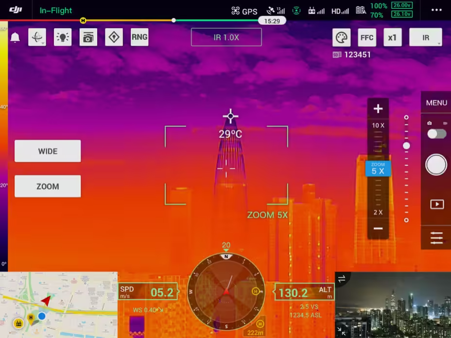
Spot Meter
Tap a point to get a real-time reading of the surface temperature.
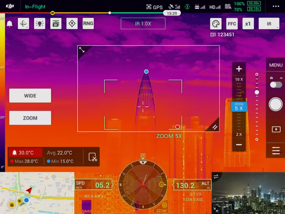
Area Measurement
Select an area to view the lowest, highest, and average temperatures.
Applications With Matrice 350
The compatibility between the DJI Zenmuse H20T and Matrice 350 enables a wide range of applications across various sectors, enhancing the ability to collect and analyze critical data efficiently:
Disaster Management
Rapid Mapping of Affected Areas: In the aftermath of natural disasters, the Matrice 350 can quickly deploy the DJI Matrice 300 RTK Zenmuse H20T to map affected regions. High-resolution imagery assists emergency services in assessing damage and planning rescue operations effectively.
Real-Time Situational Awareness: The thermal imaging capabilities of the H20T allow for monitoring of heat signatures, aiding in identifying hotspots, such as areas with ongoing fires or collapsed structures, facilitating swift responses.
Environmental Monitoring
Wildlife Surveys: The DJI Zenmuse H20T product's high-resolution and thermal cameras enable comprehensive wildlife surveys, allowing researchers to monitor populations and behaviors without intrusive methods. This is critical for conservation efforts and understanding ecological dynamics.
Habitat Assessments: The drone can be used to collect extensive data on environmental conditions, helping in habitat assessments and the identification of changes in land use, vegetation, and water bodies.
Infrastructure Inspection
Comprehensive Inspections: The Matrice 350 enhances the DJI Matrice 300 RTK Zenmuse-H20T product's ability to perform detailed inspections of infrastructure such as pipelines, power lines, and wind turbines. This can significantly reduce the time and resources required for manual inspections.
Data Integration: The DJI Zenmuse H20T can collect a variety of data types (visual, thermal, and LIDAR) simultaneously, providing a comprehensive overview of infrastructure health, which can be integrated into asset management systems for ongoing monitoring.
Construction and Surveying
Efficient Site Monitoring: The Matrice 350 can be used to monitor construction sites, providing real-time updates on progress and safety compliance. This allows project managers to make informed decisions and address any issues as they arise.
Accurate Data Collection: The combination of high-resolution imaging and advanced sensors facilitates precise surveying tasks, enabling engineers to create accurate 3D models and topographical maps.
DJI Zenmuse H20T: More Details
The DJI Zenmuse H20T stands as a transformative tool in the realm of aerial imaging, offering an unparalleled combination of optical, thermal, and zoom capabilities. Designed for use with the Matrice 300 RTK and Matrice 350 drones, this multi-sensor payload enhances operational efficiency across various industries. Its robust features, including high-resolution cameras and advanced thermal imaging, empower professionals to execute critical tasks such as infrastructure inspections, environmental monitoring, and disaster management with remarkable precision.
The H20T’s versatility extends its utility to numerous applications, including public safety and search and rescue missions, where real-time data can significantly influence decision-making. Its capability to capture data from multiple sensors simultaneously allows for comprehensive situational awareness, making it invaluable in emergency situations. Are you looking for the latest Zenmuse H20T Price? If yes, contact our sales team to receive the best rate.
Moreover, compatibility with the Matrice 300 RTK and Matrice 350 not only enhances the payload's performance but also offers advanced control features and improved stability, further broadening its application scope. Whether in challenging environments or demanding conditions, the Zenmuse H20T consistently delivers high-quality imaging, making it a game-changer for professionals across various sectors.
DJI Zenmuse H20T: Get This Product Now!
The DJI Zenmuse H20T is not just a tool but a vital asset that revolutionizes aerial operations, driving efficiency and enhancing safety in critical applications. As industries increasingly rely on aerial technology, the H20T stands out as a premier solution, promising to elevate standards in data collection and analysis. Are you looking for the latest Zenmuse H20T Price? If yes, contact our sales team to receive the best rate.
FAQ’s on DJI Zenmuse H20T
The H20T is equipped with high-resolution imaging, a 20 MP optical camera, and a thermal camera with advanced capabilities. This allows for detailed inspections of infrastructure, enabling operators to identify issues such as heat leaks, structural integrity problems, and other critical insights.
The H20T is particularly beneficial for industries such as public safety, agriculture, construction, energy, and environmental monitoring, providing essential data for decision-making and operational efficiency.
The H20T’s thermal camera performs exceptionally well in low-light environments, making it a valuable tool for nighttime operations such as search and rescue missions or monitoring wildlife.
The DJI Zenmuse H20T features a hybrid optical zoom capability of up to 23x, with a maximum digital zoom of 200x, allowing for detailed observation of distant objects without sacrificing image quality.
Yes, the H20T is designed to capture data from its optical, thermal, and zoom cameras simultaneously. This feature enhances situational awareness and allows for comprehensive analysis during missions.
The H20T’s advanced sensors provide high-resolution images and thermal data, enabling thorough assessments of ecosystems, wildlife habitats, and environmental changes. This data is critical for researchers and conservationists.
The DJI Zenmuse H20T is specifically designed to work with the Matrice 300 RTK and Matrice 350 drones, ensuring optimal performance and seamless integration.
The H20T is equipped with a Class 1M laser rangefinder, which is designed to be safe for operation and complies with international safety standards. Additionally, it features robust data encryption for secure data transmission during flights.
The H20T can quickly map affected areas using its high-resolution and thermal imaging capabilities, allowing for real-time assessments of disaster zones. This information is vital for emergency responders to plan and coordinate relief efforts effectively.
By providing detailed thermal images, the H20N allows farmers to assess crop health and optimize irrigation and fertilization practices.
1. We ship our products all over India within 3-5 working days. This includes all 28 states and 8 Union Territories. We do not offer international shipping at this time. We apologize for any inconvenience caused.
2. We ship our products through our delivery partner Shree Tirupati Courier Services PVT. LTD . (http://www.shreetirupaticourier.net/ ) and DTDC Express LTD. (https://www.dtdc.in/index.asp). Shree Tirupati Courier has over 1500 centers in more than 21 states rest are covered by DTDC and its jargon of GPS-connected trucks.
Once we receive an order before 4 pm and we have received the payment at our bank we can process the order the very same day (if it’s a working day i.e. Monday to Saturday). If however, we receive it after 4 pm then we process the order the next working day.
3. As promised on our product page we will bear the entire charges of shipping to your location.
4. It takes around 3-5 working days to deliver the products anywhere in the country. They ship it via the above-mentioned couriers in the surface transit system. However, if you want a quicker delivery you can raise a request by getting in touch with us before placing the order(or within one hour of placing the order) through mail support@mavdrones.com or call us at +91 9330328517 We will arrange Air shipping in that case. You will receive the product within 1-3 working days in that case.
5. After shipping we will give you the tracking id within 2 hours of shipping. In case we ship through Shree Tirupati Courier then you can visit http://www.shreetirupaticourier.net/Frm_DocTrack.aspx?docno=%number% This page of them and put your tracking id and can get real-time updates through this tracking platform. However, if we ship through DTDC Express then you need to visit https://www.dtdc.in/tracking.asp for tracking shipping updates.
6. We have several options for sending you the tracking id i.e. we can send it in the mail, WhatsApp, or telegram.
7. If you have any problems with the delivery like:
7A. Delayed shipment: If the shipment is delayed by any chance of any more than 3-5 working days then you have the right to demand a full refund which will be processed as per our refund policy which you can see at our RETURNS< EXCHANGES AND REFUNDS POLICY or if you are willing to cooperate with us then we can enquire with the shipping company and try and find out why the delay is happening. In the latter case, we can either work with the shipping company and try and deliver the transiting item as soon as possible or we can ship a new product to your location through a different courier partner.
7B. Receiving a broken item: We strongly suggest you should make an unboxing video of the product and also keep recording till you successfully fly the drone. Therefore, if you receive a broken item we can identify it from the video and can process a RETURN, EXCHANGE, or Refund as per your wish.
8. Public Holidays and Force Majeure:
Please note that the delivery timeframe may be affected during public holidays and unforeseen circumstances beyond our control (Such as natural disasters, strikes, or transportation disruptions). We appreciate your understanding in such situations.










Reviews
Clear filtersThere are no reviews yet.