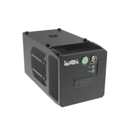
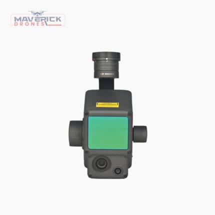
GreenValley LiAir H800
₹1,829,000.00 Incl. GST. Claimable with B2B Billing.
Specifications:
Detection Range: 350m @ 10% reflectance
Accuracy (Vertical): ±5cm
Typical Flight Speed: 5-10m/s
Memory: 256GB TF Card
And many more…
- 7 Days Return, Exchange & Refund Policy.
- Free Delivery within 3 to 5 Days.
- Assured Product Quality. We deals with only Genuine Products.
- Peace of mind Warranty. Check Our Warranty Policy.
- Contact Us for Any Assistance.
Guaranteed Safe Checkout
Unlock Precision Mapping With GreenValley LiAir H800 LiDAR System
The GreenValley LiAir H800 LiDAR System is an advanced system (LiDAR) engineered to deliver exceptional accuracy and performance in aerial mapping and surveying. This cutting-edge solution is designed to meet the rigorous demands of professionals across various industries, from environmental monitoring to infrastructure planning. With its robust specifications and seamless integration with popular UAV platforms like the Matrice series, the GreenValley H800 LiAir sets a new standard in precision, reliability, and efficiency. This product is a great option if you are planning to conduct a detailed LiDAR Survey.
VISIT THIS CATEGORY PAGE TO EXPLORE MORE SUCH PRODUCTS.
GreenValley LiAir H800 LiDAR System: Key Specifications
- Detection Range: 350m @ 10% reflectance
- Accuracy (Vertical): ±5cm
- Typical Flight Speed: 5-10m/s
- Memory: 256GB TF Card
- Weight: 2.2kg
- Voltage: 18~24V
- Power Consumption: 61W
- Communication: WIFI
- Operating Temperature: -20~50℃
- Storage Temperature: -30~60℃
LiDAR Unit:
- Wavelength: 1535nm
- Number of Channels: 3
- Field of View (FOV): 100°
- Repeatability Accuracy: 5mm
- Number of Returns: Unlimited waveform returns
- Data Frequency: 100~1000KHZ
Inertial Navigation System:
- GNSS: GPS, GLONASS, BeiDou
- Azimuth Accuracy: 0.01°
- IMU Data Frequency: 1kHZ
- Attitude Accuracy: 0.005°
Camera:
- Pixels: 26MP
- Focal Length: 16mm/24mm (Equiv. Focal Length)
- Image Size: 6252×4168
Software:
- Control Software: GreenValley Pre-processing LiGeoreference
- Post-processing: LiDAR360/LiPowerline (Optional)
Utility Across Industries
The GreenValley LiAir H800 LiDAR System is ideal for a wide range of applications, including but not limited to environmental monitoring, forestry management, infrastructure development, and urban planning. Its ability to detect objects with high precision and deliver detailed point clouds makes it an invaluable tool for professionals who require accurate data for decision-making. Whether you're conducting a detailed LiDAR Survey, capturing high-resolution LiDAR Point Clouds, or engaging in LiDAR Mapping, the GreenValley H800 LiAir ensures you get the data you need with unparalleled accuracy. This product is great for more complex LiDAR Scanning missions.
Are You Looking For The Best LiAir H800 by GreenValley system? If Yes, Do Contact Our Sales Team Today.
Why Choose The GreenValley LiAir H800 LiDAR System?
Choosing the GreenValley LiAir H800 LiDAR System means investing in a system LiDAR that offers top-tier performance and reliability. With a detection range of up to 350 meters and vertical accuracy of ±5cm, this system provides the precision needed for high-stakes projects. The system's advanced GNSS and inertial navigation features ensure that your data is accurate and consistent, even in challenging conditions. Whether you're working on a large-scale infrastructure project or conducting a detailed environmental survey, the GreenValley H800 LiAir delivers the LiDAR Data necessary for success. This product is great for more complex LiDAR Scanning missions.
Industry Adoption And Reviews
The GreenValley LiAir H800 LiDAR System has quickly become a favorite among professionals across various sectors. Users praise its reliability, ease of use, and the high quality of its LiDAR Data. Whether you're in construction, mining, forestry, or any other industry that relies on precise mapping, the H800 LiAir by GreenValley is a proven solution that enhances your operational efficiency and data accuracy. This product is great for more complex LiDAR Scanning missions.
Are You Looking For The Best LiAir H800 UAV system? If Yes, Do Contact Our Sales Team Today.
Seamless Compatibility With Matrice Series Drones
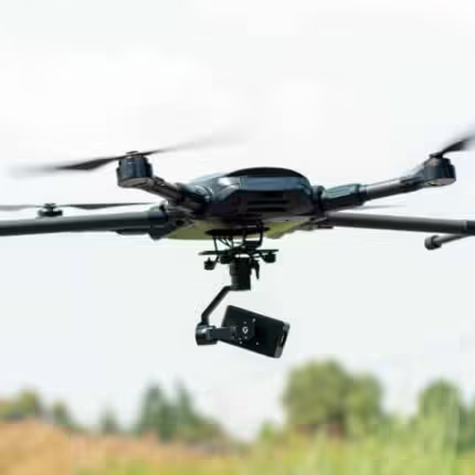
The GreenValley LiAir H800 LiDAR System is designed for seamless integration with DJI's Matrice series drones, making it a versatile choice for professionals who rely on these robust UAV platforms. Whether you're using the Matrice 200, 300, or 600 series, the H800 LiAir can be easily mounted and configured to work in harmony with these drones, leveraging their advanced flight capabilities to maximize the potential of your system lidar.
By pairing the GreenValley LiAir H800 LiDAR System with a Matrice drone, users can take advantage of the Matrice series' exceptional flight stability, extended flight times, and ability to carry heavier payloads, allowing for longer and more complex LiDAR Scanning missions. This compatibility ensures that the H800 LiAir can be deployed in a wide range of environments, from urban areas requiring precise mapping to remote regions where detailed topographical data is essential. This product is a great option if you are planning to conduct a detailed LiDAR Survey.
Furthermore, the Matrice series' advanced obstacle avoidance systems and AI-driven flight planning features complement the GreenValley LiAir H800 LiDAR System's high-resolution LiDAR Data capture, ensuring that missions are not only accurate but also safe and efficient. This combination is particularly beneficial for industries such as infrastructure inspection, forestry management, and environmental monitoring, where precision and reliability are paramount. This product is a great option if you are planning to conduct a LiDAR Mapping operation.
The seamless integration of the GreenValley LiAir H800 LiDAR System with the Matrice series drones ultimately enhances the overall capabilities of your UAV operations, making it easier to capture detailed, high-quality LiDAR Data across various applications. This product is a great option if you are planning to conduct a LiDAR Mapping operation.
Are You Looking For The Best GreenValley LiAir H800 Drone? If Yes, Do Contact Our Sales Team Today.
GreenValley LiAir H800 LiDAR System: Place Your Order Now!
The GreenValley LiAir H800 LiDAR System is more than just a system lidar—it's a comprehensive solution designed to elevate your aerial mapping and surveying capabilities. With its advanced features, compatibility with leading UAV platforms like the Matrice series, and proven performance across multiple industries, the H800 LiAir is the ideal choice for professionals seeking precision, reliability, and efficiency. Whether you're mapping complex terrains or conducting detailed surveys, the GreenValley H800 LiAir is equipped to meet and exceed your expectations, making it a worthy investment for your LiDAR Survey and mapping needs. The affordable GreenValley LiAir H800 Price makes this product a great buy.
1. We ship our products all over India within 3-5 working days. This includes all 28 states and 8 Union Territories. We do not offer international shipping at this time. We apologize for any inconvenience caused.
2. We ship our products through our delivery partner Shree Tirupati Courier Services PVT. LTD . (http://www.shreetirupaticourier.net/ ) and DTDC Express LTD. (https://www.dtdc.in/index.asp). Shree Tirupati Courier has over 1500 centers in more than 21 states rest are covered by DTDC and its jargon of GPS-connected trucks.
Once we receive an order before 4 pm and we have received the payment at our bank we can process the order the very same day (if it’s a working day i.e. Monday to Saturday). If however, we receive it after 4 pm then we process the order the next working day.
3. As promised on our product page we will bear the entire charges of shipping to your location.
4. It takes around 3-5 working days to deliver the products anywhere in the country. They ship it via the above-mentioned couriers in the surface transit system. However, if you want a quicker delivery you can raise a request by getting in touch with us before placing the order(or within one hour of placing the order) through mail support@www.mavdrones.com or call us at +91 9330328517 We will arrange Air shipping in that case. You will receive the product within 1-3 working days in that case.
5. After shipping we will give you the tracking id within 2 hours of shipping. In case we ship through Shree Tirupati Courier then you can visit http://www.shreetirupaticourier.net/Frm_DocTrack.aspx?docno=%number% This page of them and put your tracking id and can get real-time updates through this tracking platform. However, if we ship through DTDC Express then you need to visit https://www.dtdc.in/tracking.asp for tracking shipping updates.
6. We have several options for sending you the tracking id i.e. we can send it in the mail, WhatsApp, or telegram.
7. If you have any problems with the delivery like:
7A. Delayed shipment: If the shipment is delayed by any chance of any more than 3-5 working days then you have the right to demand a full refund which will be processed as per our refund policy which you can see at our RETURNS< EXCHANGES AND REFUNDS POLICY or if you are willing to cooperate with us then we can enquire with the shipping company and try and find out why the delay is happening. In the latter case, we can either work with the shipping company and try and deliver the transiting item as soon as possible or we can ship a new product to your location through a different courier partner.
7B. Receiving a broken item: We strongly suggest you should make an unboxing video of the product and also keep recording till you successfully fly the drone. Therefore, if you receive a broken item we can identify it from the video and can process a RETURN, EXCHANGE, or Refund as per your wish.
8. Public Holidays and Force Majeure:
Please note that the delivery timeframe may be affected during public holidays and unforeseen circumstances beyond our control (Such as natural disasters, strikes, or transportation disruptions). We appreciate your understanding in such situations.
Related products
Mini Z10TIR DJI Gimbal 1080p HD Camera Thermal Imaging Tracking Camera
In stock
₹1,835,999.99 Incl. GST. Claimable with B2B Billing.DJI Zenmuse H20N – UAV Payload
In stock
DJI Zenmuse L1 Lidar- Versatile UAV Payload
In stock
₹682,500.00 Incl. GST. Claimable with B2B Billing.ZIR25T Professional 3-axis High-precise FOC Program with Powerful 25mm Thermal Imager
In stock
₹575,999.88 Incl. GST. Claimable with B2B Billing.









Reviews
Clear filtersThere are no reviews yet.