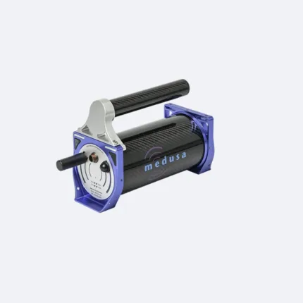
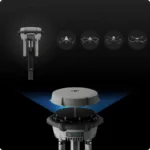
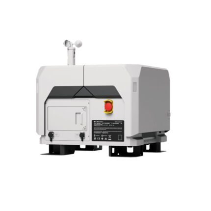
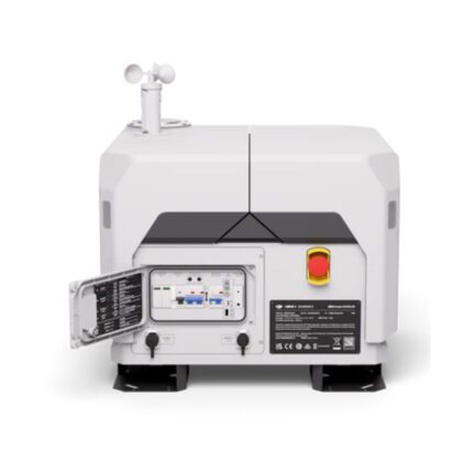
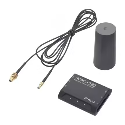
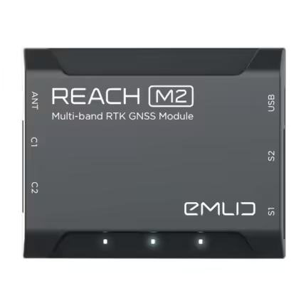
D-RTK 3 Base Station- Multifunctional Station
DRTK 3 Base Station Specifications-
BDS: B1I, B2I, B3I, B1C, B2a, B2b
GALILEO: E1, E5a, E5b, E6
GLONASS: L1, L2
QZSS: L1C/A, L2C, L5
L-Band
- 7 Days Return, Exchange & Refund Policy.
- Free Delivery within 3 to 5 Days.
- Assured Product Quality. We deals with only Genuine Products.
- Peace of mind Warranty. Check Our Warranty Policy.
- Contact Us for Any Assistance.
Guaranteed Safe Checkout
DRTK 3 Base Station: Precision At Its Peak!
The new D-RTK 3 Base Station integrates high-performance antennas and receiver modules capable of tracking and resolving data from major global satellite navigation systems, and it supports multiple data transmission links.
With these outstanding features, it can serve as a base station to provide centimeter-level positioning for multiple drones simultaneously or extend the operational range of drones in relay station mode. The new rover station mode, combined with the DJI Enterprise app and DJI Terra, provides a comprehensive solution for high-precision aerial surveying applications, ensuring a secure and accurate operation.
Multiple Modes, Versatile Control
Base Station Mode: Supports Simultaneous Operation of Multiple Models
DRTK 3 supports the new O4 Enterprise video transmission with four external directional antennas, enabling 15 km [1] video transmission in base station broadcast mode while ensuring stable signals in all directions. Operators only need to set up one D-RTK 3 Base Station without additional configuration, allowing multiple drones to connect to the base station and access centimeter-level positioning.
Relay Station Mode [2] : Break Through Limitations
Switch D-RTK 3 Base Station to Relay Station Mode [2] and set it up at an elevated location in areas with significant signal obstructions, such as urban environments or valleys. This will enhance the video transmission distance and extend the operational range of the Matrice 4 series up to 25 kilometers [3].
DRTK 3 supports obstruction sensing with the Matrice 4 Series, allowing real-time calculations of obstructions and signal quality between the relay station, the remote controller, and drone. Operators can adjust the drone's position based on prompts from the remote controller to ensure optimal communication quality.
Besides serving as a base station, DRTK 3 can also be used as a rover station to collect control point coordinates, enhancing the accuracy of UAV aerial survey and improving survey precision.
Technical Specifications Of DRTK 3 Base Station
GNSS Receiver
GNSS Frequency
- GPS: L1C/A, L2C, L5
BDS: B1I, B2I, B3I, B1C, B2a, B2b
GALILEO: E1, E5a, E5b, E6
GLONASS: L1, L2
QZSS: L1C/A, L2C, L5
L-Band
System Accuracy
Base Station Mode (Broadcast Mode) and Relay Station Mode
Base Station Accuracy:
Single Point Accuracy (Uncalibrated):
Horizontal: 1.5 m (RMS)
Vertical: 3.0 m (RMS)Satellite-Based Differential Accuracy:
Convergence Time: 20 mins
Horizontal: 30 cm (RMS)
Vertical: 40 cm (RMS)Network RTK Calibration**:
Horizontal: 1.0 cm (RMS) + 1 ppm
Vertical: 3.0 cm (RMS) + 1 ppmRover Station Mode*
RTK Accuracy (Fixed Survey):
Horizontal: 0.8 cm (RMS) + 1 ppm
Vertical: 1.5 cm (RMS) + 1 ppmRTK Accuracy (Tilt Survey)***:
Angle Range: 0° to 60°
Horizontal: 8 mm + 0.7 mm/° tilt (accuracy <2 cm within 30°)* Measurement accuracy depends on various factors. This value is obtained under normal conditions with an unobstructed view, good satellite distribution, low ionospheric activity, and no electromagnetic interference or multipath effects.
** Base station calibration coordinate accuracy depends on various factors. For surveying, high-precision flight paths, etc., it is recommended to calibrate during periods of inactive ionosphere, in open, unobstructed environments with no electromagnetic interference or multipath effects, using four or more GNSS systems.
*** Intense vibrations and rapid rotations can affect the accuracy of the inertial measurement unit.
Satellite-Based Precise Point Positioning*
Supported Frequencies: BDS B2b, GALILEO E6**, L-BAND**
Convergence Time: 20 mins
Horizontal: 30 cm (RMS)
Vertical: 40 cm (RMS)* Measurement accuracy depends on various factors. This value is obtained under normal conditions with an unobstructed view, good satellite distribution, low ionospheric activity, and no electromagnetic interference or multipath effects.
** Will be supported in later versions.
Differential Data Transmission Format
- When used as a base station or relay station, records RTCM 3.2 raw observation data in DAT format.
In rover station mode or in calibration mode for base and relay stations:
1. Supports RTCM v3.0, v3.1, v3.2, v3.3, MSM4, MSM5, MSM6, MSM7 protocols.
2. It is recommended to use receivers that support four or more GNSS systems.
Initialization Reliability
- >99.9%
Video Transmission
Video Transmission System
- O4 Enterprise
Operating Frequency
Relay Station Mode:
O4: 2.4 GHz/5.2 GHz/5.8 GHz
Broadcast mode:
O4: 2.4 GHz/5.8 GHz
Rover Station Mode:
BLE: 2.4 GHzOperating frequency allowed varies among countries and regions. Please refer to local laws and regulations for more information.
Transmitter Power (EIRP)
2.4000 GHz to 2.4835 GHz:
<33 dBm (FCC)
<20 dBm (CE/SRRC/MIC)5.150 GHz to 5.250 GHz:
<23 dBm (CE/FCC)5.725 GHz to 5.850 GHz:
<33 dBm (FCC)
<30 dBm (SRRC)
<14 dBm (CE)
Bluetooth
- Protocol: Bluetooth 5.1
Frequency: 2.400 GHz to 2.4835 GHz
Transmitter Power (EIRP): <10 dBm Max Transmission Distance (unobstructed, free of interference)
Base Station Mode
Between D-RTK 3 Base Station and the aircraft:
FCC: 15 km
SRRC: 12 km
CE/JP: 8 kmRover Station Mode:
Between D-RTK 3 Base Station and mobile devices: 30 m
Measured in an unobstructed outdoor environment free of interference. The above data shows the farthest communication range for one-way, non-return flights under each standard. Always pay attention to RTH reminders in the app during your flight.
Max Transmission Distance in Relay Station Mode (unobstructed, free of interference)
FCC
Between the aircraft and the relay station: 25 km
Between the relay station and the remote controller: 1 kmSRRC
Between the aircraft and the relay station: 12 km
Between the relay station and the remote controller: 1 kmCE
Between the aircraft and the relay station: 10 km
Between the relay station and the remote controller: 300 mMeasured in an unobstructed outdoor environment free of interference. The above data shows the farthest communication range for one-way, non-return flights under each standard. Always pay attention to RTH reminders in the app during your flight. The relay station should be placed in a elevated, unobstructed location to ensure clear communication between the remote controller and the aircraft.
Max Transmission Distance in Relay Station Mode (unobstructed, with interference)
Strong interference: City centers, approx. 1.5-5 km
Medium interference: Suburban areas, approx. 5-15 km
Micro interference: Remote areas/seasides, approx. 15-25 kmData is tested under FCC standards in unobstructed environments of typical interference. Only to serve as a reference and provides no guarantee as to the actual flight distance.
Max Transmission Distance in Relay Station Mode(obstructed, with interference)
Low Interference and Obstructed by Buildings: approx. 0-0.5 km
Low Interference and Obstructed by Trees: approx. 0.5-3 kmData is tested under FCC standards in unobstructed environments of typical interference. Only to serve as a reference and provides no guarantee as to the actual flight distance.
Antenna
OcuSync 4 directional antennas× 4, 2T4R
The antenna uses a standard reverse polarity SMA connector.
Electrical Properties
Power
- Relay Station: 14.5 W (max power consumption without heating; max 36.5 W with heating)
Base Station: 7 W
Rover Station: 6.2 W
Supported Power Adapter
USB PD 3.0 protocol, output voltage 9V to 15V adapter (e.g., DJI 65W Portable Charger)
When using a non-recommended charger, such as a charger with 5V-output, the D-RTK 3 Base Station can be charged only after powering off.
Power Output Port
- USB Type-C
Operating Time (Under Normal Temperature)*
Relay Station: 4 hrs
Base Station:7 hrs
Rover Station: 10 hrs* Battery performance may decrease in low temperatures; it is recommended to use power adapters that support the USB PD 3.0 protocol.
Battery
- LiPo
Capacity: 6500 mAh
Energy: 46.8 Wh
Physical Characteristics
Operating Temperature
-20° to 55°C (-4° to 131°F)
1. In normal temperature environments, charging power will be limited if the device shell temperature exceeds 48°C (118.4°F). Full power charging will resume after cooling.
2. After storage/use in low temperatures, the device needs to be brought to a normal temperature environment and allowed to warm up until the internal battery temperature is >0°C (32°F) before charging.
3. After storage/use in high temperatures, the device needs to be brought to a normal temperature environment and allowed to cool down until the internal battery temperature is <45°C (113°F) before charging.
Altitude
- 6000 m
Protection Rating
IP67*
* Please make sure all rubber plug interfaces on the body are properly installed.
Drop Resistance
- 2 m drop with pole
Dimensions
- 163 × 89 mm (without OcuSync Directional Antennas)
Weight
- Approx. 1.26 kg (2.78 lbs)
1. We ship our products all over India within 3-5 working days. This includes all 28 states and 8 Union Territories. We do not offer international shipping at this time. We apologize for any inconvenience caused.
2. We ship our products through our delivery partner Shree Tirupati Courier Services PVT. LTD . (http://www.shreetirupaticourier.net/ ) and DTDC Express LTD. (https://www.dtdc.in/index.asp). Shree Tirupati Courier has over 1500 centers in more than 21 states rest are covered by DTDC and its jargon of GPS-connected trucks.
Once we receive an order before 4 pm and we have received the payment at our bank we can process the order the very same day (if it’s a working day i.e. Monday to Saturday). If however, we receive it after 4 pm then we process the order the next working day.Â
3. As promised on our product page we will bear the entire charges of shipping to your location.
4. It takes around 3-5 working days to deliver the products anywhere in the country. They ship it via the above-mentioned couriers in the surface transit system. However, if you want a quicker delivery you can raise a request by getting in touch with us before placing the order(or within one hour of placing the order) through mail support@www.mavdrones.com or call us at +91 9330328517 We will arrange Air shipping in that case. You will receive the product within 1-3 working days in that case.
5. After shipping we will give you the tracking id within 2 hours of shipping. In case we ship through Shree Tirupati Courier then you can visit http://www.shreetirupaticourier.net/Frm_DocTrack.aspx?docno=%number% This page of them and put your tracking id and can get real-time updates through this tracking platform. However, if we ship through DTDC Express then you need to visit https://www.dtdc.in/tracking.asp for tracking shipping updates.
6. We have several options for sending you the tracking id i.e. we can send it in the mail, WhatsApp, or telegram.
7. If you have any problems with the delivery like:
7A. Delayed shipment: If the shipment is delayed by any chance of any more than 3-5 working days then you have the right to demand a full refund which will be processed as per our refund policy which you can see at our RETURNS< EXCHANGES AND REFUNDS POLICY or if you are willing to cooperate with us then we can enquire with the shipping company and try and find out why the delay is happening. In the latter case, we can either work with the shipping company and try and deliver the transiting item as soon as possible or we can ship a new product to your location through a different courier partner.
7B. Receiving a broken item: We strongly suggest you should make an unboxing video of the product and also keep recording till you successfully fly the drone. Therefore, if you receive a broken item we can identify it from the video and can process a RETURN, EXCHANGE, or Refund as per your wish.
8. Public Holidays and Force Majeure:
Please note that the delivery timeframe may be affected during public holidays and unforeseen circumstances beyond our control (Such as natural disasters, strikes, or transportation disruptions). We appreciate your understanding in such situations.
Reviews
Clear filtersThere are no reviews yet.