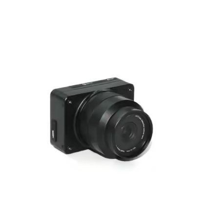
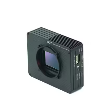
ADTi 45MP 45PRO Surveyor Drone Mapping Cameras
₹414,259.06 – ₹461,603.02 Incl. GST. Claimable with B2B Billing.
Specifications:
Full-frame Sony CMOS Sensor: 44.7 effective megapixels
Mechanical Shutter: Lightweight inter-mirror design with speeds from 1/100 to 1/10000 seconds
Continuous Shooting: Up to 2.0 frames per second with an exposure interval of ≥0.5s
And many more…
- 7 Days Return, Exchange & Refund Policy.
- Free Delivery within 3 to 5 Days.
- Assured Product Quality. We deals with only Genuine Products.
- Peace of mind Warranty. Check Our Warranty Policy.
- Contact Us for Any Assistance.
Guaranteed Safe Checkout
ADTi 45MP 45PRO Surveyor Drone Mapping Cameras: The Latest Innovation For Drones
Introducing the ADTi 45MP 45PRO Surveyor Drone Mapping Camera System. This advanced system is intended for expert aerial mapping as well as surveying. ADTi 45MP 45PRO Drone Mapping Camera System comes with accuracy and cutting-edge technology. This camera system is perfect for surveyors. Surveyors who are seeking high-resolution, reliable, and efficient aerial mapping capabilities.
ADTi 45MP 45PRO Surveyor Drone Mapping Cameras: Key Features
An in-house designed 45 MP full-frame camera module powers the ADTi 45PRO. That utilizes the Sony IMX 366 back-illuminated sensor. This sensor ensures exceptional image clarity and detail. This camera system for ADTi 45MP 45PRO Surveyor Mapping Drones can capture high-resolution images at 8192 x 5460 (45 MP, 3:2). The Socionext Imaging processor, Milbeaut®, further enhances image quality while maintaining low heat generation.
THE ADTI 45MP 45PRO SURVEYOR DRONE MAPPING CAMERAS ARE RELATED WITH THE ADTI 42MP 42S V1 SURVEYOR DRONE MAPPING CAMERAS. WANT TO EXPLORE MORE SUCH PRODUCTS? IF YES, VISIT THIS CATEGORY PAGE.
ADTi 45MP 45PRO Surveyor Drone Mapping Cameras: Advanced Camera Specifications
- Full-frame Sony CMOS Sensor: 44.7 effective megapixels
- Mechanical Shutter: Lightweight inter-mirror design with speeds from 1/100 to 1/10000 seconds
- Continuous Shooting: Up to 2.0 frames per second with an exposure interval of ≥0.5s
- Video Capture: Full HD 1920x1080 at 60p and 640x480 at 30p, outputting in MP4 format with HDMI connection for live video streaming
Customizable Optics: ADTi offers a range of fixed-focus lenses. That can be optimized for various mapping requirements:
- 21mm Fixed Lens: 92° diagonal FOV, distortion <0.3%, focusing range from 50 meters to infinity
- 40mm Fixed Lens: 57° diagonal FOV, distortion <0.037%, focusing range from 50 meters to infinity
- 56mm Fixed Lens: 42.2° diagonal FOV, distortion <0.3%, focusing range from 50 meters to infinity All lenses feature a fixed aperture of F5.6. Therefore, ensuring consistent performance across different mapping scenarios.
ADTi 45MP 45PRO Surveyor Drone Mapping Cameras: Integrated Functionality
- Geo-Tagging and PPK Compatibility: Built-in multi-interface hot shoe for precise PPK (Post-Processing Kinematic). As well as geo-tagging with Pixhawk flight controllers (ADTi POS&CTRL unit required).
- Durable Design: Constructed with a full aluminum structure for robustness and longevity.
- Connectivity: Equipped with an Ethernet port for real-time video streaming.
ADTi 45MP 45PRO Surveyor Drone Mapping Cameras: Efficient Power And Compact Design
- Power: Operates on 12-28V DC from Lipo or Li-ion batteries
- Compact and Lightweight: The camera measures 7.2 x 6.8 x 10.6 cm and weighs 270 g with the 21mm lens and 180 g with the 40mm or 56mm lenses. The entire package, including accessories, weighs 800 g.
ADTi 45MP 45PRO Surveyor Drone Mapping Cameras: Specifications And Overview
Image Sensor
- Type: CMOS, Sony IMX 366 back-illuminated
- Size: 876mm² (36.5 x 24mm)
- Pixel Size: 4.4 μm x 4.4 μm
- Aspect Ratio: 3:2
Image Capture
- Resolution: 8192 x 5460 (45 MP)
- File Format: JPEG
Shutter
- Type: Mechanical, replaceable
- Speed: 1/100 to 1/10000 seconds
- Continuous Mode: 2.0 frames/second
- Exposure Interval: ≥0.5s
Video Capture
- Resolution: 1920x1080 (60p), 640x480 (30p)
- File Format: MP4
- HD Output: HDMI
Lens Options
- 21mm: Manual fixed focus, FOV 92°, aperture F5.6
- 40mm: Manual fixed focus, FOV 57°, aperture F5.6
- 56mm: Manual fixed focus, FOV 42.2°, aperture F5.6
Camera Dimensions and Weight
- Size: 7.2 x 6.8 x 10.6 cm
- Weight: 270g (21mm lens), 180g (40mm or 56mm lens)
- Package Size: 14.5 x 10 x 6 cm
- Package Weight: 800g
- Operating Temperature: -10 to 40 °C
ADTi 45MP 45PRO Surveyor Drone Mapping Cameras: Unmatched Utility And Versatility
The ADTi 45MP 45PRO Drone Mapping Camera System is not just a camera. This system for ADTi 45MP 45PRO Surveyor Mapping Drones is a comprehensive solution. For a variety of professional applications. From land surveying and geospatial mapping to infrastructure inspection and environmental monitoring. These ADTi 45MP 45PRO Surveyor Aerial Mapping Cameras adapt seamlessly to every need. This High-Resolution Drone Mapping Camera includes high-resolution capabilities. That allows for detailed, accurate data collection. Thus making these surveyor drone cameras indispensable for surveyors and mapping professionals.
ADTi 45MP 45PRO Surveyor Drone Mapping Cameras: Enhanced Surveying Efficiency
This 45MP Drone Camera For Mapping comes with advanced geo-tagging and PPK functionality. The ADTi 45MP 45PRO dramatically reduces the time and effort required for post-processing. This ensures that you can deliver precise, geo-referenced data quickly and efficiently. The compatibility with Pixhawk flight controllers means integration into existing drone systems. That is smooth and hassle-free, which further enhances the operational efficiency.
ADTi 45MP 45PRO Surveyor Drone Mapping Cameras: Built For Durability And Performance
The 45MP Drone Camera For Mapping is designed to withstand the rigors of fieldwork. This product is manufactured using a full aluminum structure. This 45MP Drone Camera For Mapping includes a robust build. That ensures complete reliability even in challenging environments. While the lightweight design minimizes the impact on drone flight performance. The inclusion of an Ethernet port for live video streaming adds another layer of utility. Therefore, real-time monitoring and adjustments during flights become easier.
ADTi 45MP 45PRO Surveyor Drone Mapping Cameras: Commercial Viability
It is ideal for businesses and professionals in the surveying and mapping industries. This Aerial Mapping Drone Camera offers a significant return on investment. This camera system is available with high-resolution imaging. Further combined with advanced features like direct geo-tagging and PPK compatibility. This translates to faster project completion times and higher accuracy. This efficiency reduces operational costs. As well as enhances the quality of service you can offer your client.
ADTi 45MP 45PRO Surveyor Drone Mapping Cameras: Purchase Now
ADTi 45MP 45PRO Surveyor Drone Mapping Camera System is the ultimate tool for surveyors and mapping professionals. That combines advanced imaging technology, customizable optics, and robust design. To deliver unparalleled performance in aerial mapping and surveying tasks. With its exceptional image quality, integrated functionality, and durable build. ADTi 45MP 45PRO Surveyor Drone Mapping Cameras are the top choice for those demanding precision in their aerial mapping endeavors. Embrace the future of surveying with the ADTi 45MP 45PRO and elevate your projects to new heights.
| Lens Type Select the Lens Type from the list below |
21mm ,40mm ,56mm |
|---|
1. We ship our products all over India within 3-5 working days. This includes all 28 states and 8 Union Territories. We do not offer international shipping at this time. We apologize for any inconvenience caused.
2. We ship our products through our delivery partner Shree Tirupati Courier Services PVT. LTD . (http://www.shreetirupaticourier.net/ ) and DTDC Express LTD. (https://www.dtdc.in/index.asp). Shree Tirupati Courier has over 1500 centers in more than 21 states rest are covered by DTDC and its jargon of GPS-connected trucks.
Once we receive an order before 4 pm and we have received the payment at our bank we can process the order the very same day (if it’s a working day i.e. Monday to Saturday). If however, we receive it after 4 pm then we process the order the next working day.
3. As promised on our product page we will bear the entire charges of shipping to your location.
4. It takes around 3-5 working days to deliver the products anywhere in the country. They ship it via the above-mentioned couriers in the surface transit system. However, if you want a quicker delivery you can raise a request by getting in touch with us before placing the order(or within one hour of placing the order) through mail support@www.mavdrones.com or call us at +91 9330328517 We will arrange Air shipping in that case. You will receive the product within 1-3 working days in that case.
5. After shipping we will give you the tracking id within 2 hours of shipping. In case we ship through Shree Tirupati Courier then you can visit http://www.shreetirupaticourier.net/Frm_DocTrack.aspx?docno=%number% This page of them and put your tracking id and can get real-time updates through this tracking platform. However, if we ship through DTDC Express then you need to visit https://www.dtdc.in/tracking.asp for tracking shipping updates.
6. We have several options for sending you the tracking id i.e. we can send it in the mail, WhatsApp, or telegram.
7. If you have any problems with the delivery like:
7A. Delayed shipment: If the shipment is delayed by any chance of any more than 3-5 working days then you have the right to demand a full refund which will be processed as per our refund policy which you can see at our RETURNS< EXCHANGES AND REFUNDS POLICY or if you are willing to cooperate with us then we can enquire with the shipping company and try and find out why the delay is happening. In the latter case, we can either work with the shipping company and try and deliver the transiting item as soon as possible or we can ship a new product to your location through a different courier partner.
7B. Receiving a broken item: We strongly suggest you should make an unboxing video of the product and also keep recording till you successfully fly the drone. Therefore, if you receive a broken item we can identify it from the video and can process a RETURN, EXCHANGE, or Refund as per your wish.
8. Public Holidays and Force Majeure:
Please note that the delivery timeframe may be affected during public holidays and unforeseen circumstances beyond our control (Such as natural disasters, strikes, or transportation disruptions). We appreciate your understanding in such situations.
Related products
Hobbywing X11 MAX Motor – 11122 18S 60KV 48175 Propeller
In stock
₹68,440.00 Incl. GST. Claimable with B2B Billing.SIYI ZR10 2K 4MP QHD 30X Hybrid Zoom Gimbal Camera
In stock
₹67,258.82 Incl. GST. Claimable with B2B Billing.Skydroid H12 Remote Controller Without Camera
In stock
₹41,888.82 Incl. GST. Claimable with B2B Billing.CUAV NEO 3 Pro GPS Module | GNSS U-BLOX M9N CAN BUS
In stock
₹17,335.00 Incl. GST. Claimable with B2B Billing.Hobbywing Plus X6 Motor With 2480 Propeller
In stock
₹15,340.00 Incl. GST. Claimable with B2B Billing.SIYI A2 Mini Ultra Wide Angle FPV Gimbal Single
In stock
₹15,338.82 Incl. GST. Claimable with B2B Billing.












Reviews
Clear filtersThere are no reviews yet.